Drive The Four Passes
If you are into scenery and are happy to go off the Garden Route for a detour, then try one of these spectacular drives:
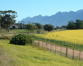
Montagu Pass
In 1843 Major Mitchell, Surveyor General of the Cape, suggested that convict labour be used to build a good road over the Outeniqua Mountains, the one which was to be called the Montagu Pass. This was approved by the Hon. John Montagu, Colonial Secretary, and in 1844 work was started on the new pass. About 250 convicts tackled the arduous task of building the new road. They were housed in two camps, the South station and the North Station. The job was completed at a cost of R71 000-00. In 1847 the pass was opened for traffic, but the official opening only took place on 19 January 1948. This was a festive affair, and the Hon. John Montagu personally opened the pass which was to be called after him. The passage over the mountains, which used to take a full three days over the tortuous Cradock Pass, could now be
accomplished within three hours (Today it hardly takes 15 minutes by car).
The engineer in charge of the work was Henry Fancourt White, an experienced road engineer from Australia, who was imported by John Montagu for the work. Henry Fancourt White’s name is perpetuated in the lovely estate, Fancourt (his mother’s surname) and in the village of Blanco. In honour of this very capable engineer, the Hon. John Montagu suggested that the little hamlet which grew up atthe foot of the pass, be called White or White’s Village. This was later
changed to the more euphonious Latin word for ‘White’ - Blanco.
Old Toll House
Originally the toll was one penny per wheel and one penny per ox. After the Tollhouse you come to the Montagu Pass Bridge. The older generation knew this as the Keurrivier se Brug - due to the Keurbome which grew here in profusion. The Divisional Council succeeded in having this old stone bridge, so artfully build, declared a National Monument. The whole Montagu Pass has also been declared a National Monument and the signposts marking the historic spots along the way were erected by the Divisional Council at the suggestion of the George Museum Society.
The vicinity of the bridge is supposed to be haunted by a man in a grey suit. Having crossed the bridge, you now approach the pass proper, with its stone wall all along the one side. The wall has unfortunately been badly damaged in parts. You will notice that on some parts of the wall the lower row of stone protrude slightly. This was done to prevent the axles of the wagons from scraping against the walls and thus becoming damaged.
The road up the pass is rather narrow and wagons could not pass abreast. Consequently the old drivers had to whistle and shout and crack their whips continuously to warn one another of their approach. The narrowest part of the pass with overhanging cliffs was called Die Noute. Going up the pass you will notice a huge rock to the left, just off the road. This is called Moertjieklip. According to the old-timers this rock was dislodged during the building of the railway line higher up (some maintain it was during the building of the pass itself). It rolled down the mountainside, pinning one of the labourers underneath and crushing him to death. One has to know Afrikaans in order to appreciated the aptness - rather rough humour of the name Moertjieklip. The next place you come to is Boshoff se Draai. According to the late Mr Beb de Swardt a certain Boshoff used to tell all and sundry what a good "touleier" he was. Leading a span of oxen was of course quite an art, it needed exact timing and deft manipulation to manoeuvre a wagon and span round a bend. Then one day the bragging Boshoff miscalculated this particular bend in the road with the result that he landed on the horns of the foreox and was tossed over the wall. After this you find to the left, the ruins of the old smithy. When most of the little buildings were still standing, the Museum Society recommended that it be declared a National Monument.
This was done, but before restoration could be tackled, trespassers had carted away most of the stones. So today we are left with only the ruins of the old smithy. Here the implements used in the building of the pass were sharpened and repaired. Convicts working on the pass were also stationed here under guard.
Now follows the Haarkantdraai - the bend where the road curves towards the right. Next you come to that part of the pass which taxed every poor beast ascending the pass to its utmost, namely the Regoptrek. This is the steepest part of the road. Having mastered this, the old-timers allowed themselves to relax for a while at Grog- Draai. The name speaks for itself. For those not in need of a strong sustenance, there was always the lovely cool water from a bubbling spring nearby.
Then you come to the Hotkantdraai where the road curves towards the left, and to Witkop se Draai from where you have a view of the white koppie. The name, Witkop se Draai, alludes to the colour of the soil. Where the road passes underneath the railway bridge, you have Stinkhoutdraai. Stinkwood trees used to grow here in profusion. Further along the road, on the right, we find the old wagon tracks cut into the stone by the wheels and remskoene (brakes) of the wagons descending from the old Cradock Pass.
And then at last, you reach the hotel at North Station. The oldest part of the ruins probably dates from approximately 1840, i.e. before the building of the Montagu Pass, and housed visitors from the days of the Cradock Pass.
Outeniqua Pass
This modern pass was located by P.A. de Villiers, the National Road Board’s location engineer who will always rank as one of the great road builders of South Africa. Its whole conception & execution-bold & majestic-ensures its status as one of the world’s grand road passes & makes it a pleasure to use. The summit (799m above sea level) is reached 14 km from George.
Drive north off the N1 through George to Oudtshoorn and then north some more along the Swartberg Pass to Prince Albert. This mountain pass is one of the most spectacular mountain passes in the world, and is you are interested in such things, it is an engineering marvel. The drive "feels" dangerous but it really isn't. It just adds to the excitement. I can't recommend it enough!
The Swartberg mountains are a magnificent backdrop to the village of Prince Albert. Once considered almost impenetrable, there are now three major gateways – the Swartberg Pass, Meiringspoort and the Seweweekspoort – linking the Central Karoo with the Little Karoo and the coast. Meiringspoort and the Swartberg Pass are on Prince Albert's doorstep. Both fall within the Swartberg Nature Reserve (whose aims are to conserve fynbos and provide water). Both offer geological and natural splendours and the construction of both were spectacular engineering feats.
Cradock Pass Day Trail
Trail Distance: 12,4km (5 hours),
This strenous and difficult walk follows the tracks that the settler' ox-wagon wheels scoured into the rocks while descending the trecherous Cradock Pass across the Outeniqua mountains from the coast to the Little Karoo. This historic trail offers fynbos, karoo veld and extensive mountain scenery and views over George.
To reach the start of the trail at the reserve offices, drive 3,7km from George towards Oudtshoorn, turn right to Witfontein and right again at the entrance gate to the Outeniqua Nature Reserve. Park at the reserve office. It ends on the north side of the Montagu Pass, 1km from the top, marked by two signboards. You will need transport waiting here. Alternatively, it is 10,9km (3 hours walk) from here down the Montagu Pass back to the start. Remember to plan your hike thoroughly and to take water. The weather conditions can change very quickly in the mountians, even if weather is good at lower altitudes. Take a wind- and waterproof anorak and warm clothing even in the summer.
George Peak Hike
Trail Distance is 17,2km or 7 hours walk
Note: 21,1km (9 hours) if combined with the Cradock Peak trail
Nearest Town: George
Look out over George, the Swartberg mountains in the Little Karoo and the coastline in the distance as you approach the summit of George Peak in the Outeniqua mountains. It is a trail with spectacular scenery and mountain fynbos. It is, however, a very difficult route. It can be combined with a climb of the Cradock Peak.
To reach the start of the route, drive 3,7km from George in the direction of Oudtshoorn. Turn right to Witfontein and right again at the entrance gate to Outeniqua Nature Reserve. Park 800m on at the reserve office and start the trail. It also ends here. Plan your hike thoroughly and take water. The weather conditions can change very quickly in the mountians, even if weather is good at lower altitudes.
Cradock Peak Hike
Trail Distance is 17km or 6 hours walk
Note: 21,1km (9 hours) if combined with the George Peak trail
Nearest Town: George
This very difficult route offers stunning views over George, the Little Karoo and the Garden Route coastline. It leads up to the Cradock Peak in the Outeniqua mountains above George. Along the way mountain fynbos, views and good birding opportunities will be your reward.
The route starts and ends at the reserve office. To reach it, drive 3,7km from George in the direction of Oudtshoorn. Turn right to Witfontein and right again at the entrance gate to Outeniqua. Park 800m on at the reserve office and start off on the trail.
Plan your hike thoroughly and take water. The weather conditions can change very quickly in the mountians, even if weather is good at lower altitudes.
This is a short and moderate day walk, with steep climbs. It links the Montagu and Outeniqua passes and provides spectacular views of the Outeniqua mountains and George. It follows through rich fynbos and extensive mountain scenery.
It starts at the old quarry on the west side of the top of the Montagu Pass, and ends at the top of the Outeniqua Pass, 14,9km from George. You will need transport waiting here.
Plan your hike thoroughly and take water. Be cautious with the weather.